Collecting Your Own Aerial Data
An exciting possibility: increasingly affordable hardware
and sophisticated software should make it available for anyone to collect
high-resolution georegistered aerial imagery. Beyond just viewing the
result, with the use of photogrammetry and ground control points, the imagery could provide a base for collecting
all the 2D and 3D features
that are the last-mile problem in modeling and visualizing the whole world.
UAVs
- There are a wide range of UAVs that can capture imagery, from
toys at the low-end to military drone surveying at the high end.
 French company Pict'Earth gave a
good presentation in 2008,
A NeoGeographical
Approach to Aerial Image Acquisition and Processing, which explains how
UAVs opens a way to do something new and important: Site Specific Base
Maps.
French company Pict'Earth gave a
good presentation in 2008,
A NeoGeographical
Approach to Aerial Image Acquisition and Processing, which explains how
UAVs opens a way to do something new and important: Site Specific Base
Maps.- Popular platforms include
RC
helicopters (gas and electric),
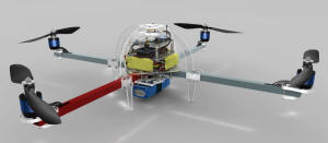
Quadrotors, and regular
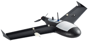
fixed-wing (and
flying wing) planes, generally of a modest size. There are degrees
of control from manual to complete autonomy. Even
the cheapest models now often
have a high degree of self-stabilization (attitude
control).
- A frequently used term is "Ready To Fly" (RTF).
- DIY Drones has a substantial community
around the open "ArduCopter" platform.
- The Parrot AR Drone ($360 and
up)
seems to be the popular low-end quadcopter
- It sends a 720p live video stream, but is really meant for remote
viewing rather than surveying, because the camera is wide-angle and
points forward, not down. It also uses Wifi for control, so you can
only go ~150' above the operator. Hobbyists have reportedly made replacement boards for the Parrot which lets
you use RC instead of Wifi (for farther range), add GPS, etc.
- SteadiDrone/a> (South Africa)
sells RTF systems from around $2,000 to $20,000 including large copters that
can lift heavy DSLR cameras.
- DJI (China) makes RTF UAVs from the quad
Phantom
($680)
- Falcon UAV sells fixed-wing UAV
systems for $13,000 to $20,000
- Sensefly swinglet CAM
(Switzerland) is a another fixed-wing
- The eBee (~$10,000) came out in 2013.
- At the high end, the GateWing X-100
is a supposedly turnkey solution, but it costs around $100,000.
Kites and Balloons
Cameras
- There are very few consumer-priced cameras that can be set to take a
high-quality still picture at regular intervals.
- As of 2013, there are basically only 4 high-megapixel fixed-lens
cameras which can take pictures continuously (commonly called time-lapse, or
more obscurely as "intervalometer"):
- Pentax Optio WG-2 (and WG-3), 16 MP, 192 g, $205 on amazon.
- Panasonic Lumix DMC-TS5, 16.1 MP, 214 g, $360 on amazon.
- Nikon Coolpix P510, 16 MP, (41.7× zoom!), 555 g, $370 on amazon.
- Ricoh GR, 16.2 megapixels, 245 g, $800 on amazon.
- As of 2014, another reasonably affordable high-quality option is the Sony A6000 (24.3 MP,
~$650) which doesn't have an intervalometer, but can be remotely triggered.
- An older option: certain Canon cameras can be hacked with CHDK (see
Unleash your camera’s inner Hulk with a free hack to the firmware)
- Smartphone camera
Processing the Imagery
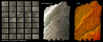
- To make an orthophoto (for visualization purposes), the video or still frames from the UAV generally need to be stitched
together (mosaicked) in a process similar to that used for panoramas.
You can also do photogrammetry to produce a DEM from the
images. Some approaches require knowing the location the camera took
the images from to some degree of precision, other approaches don't require
that information.
- Another (newer, more general) term for this process is "structure from
motion" (SfM)
- Ground Control Points (GCPs)
- Regardless of what hardware or software you use, to georeference /
georectify, you will need GCPs, which are identifiable points on the
ground with a known position. The accuracy of your GCPs determines
the accuracy of anything tied to them, so it's important to do them
well.
- Permanent GCP's are sometimes maintained by government or local
authorities.
- If you have any clearly identifiable objects in the image (such as
buildings) for which you do know their location, then those can serve as
GCPs.
- You can't just use a consumer GPS; see
Data Collection page for more
about that.
- Producing an Orthophoto
- You could, in theory, simply stich images yourself in any image
editing software, then rectify to match GCPs with software
such as Global
Mapper ($400). This is similar to the process for working with
traditional aerial photos.
- The PLOTS
MapKnitter is a free opens-source online tool
for semi-automatically stitching images, in part by overlaying them on
an existing image layer (such as Google Maps).
- Also in the open-source world, GDAL has recently incorporated a
SOC project to do image correlation (one small step in the image
processing chain)
- Producing a DEM
- LISA
Geo-Software (starting at €5000, €820 educational)
- Appears to be powerful and complex photogrammetry software, needing a good amount of training to use. They
list "UAV photogrammetry" as a field of application.
-
How to create a Digital Elevation Model from Photosynth point clouds
(2010)
- A detailed (and hacky) 25-step process moving the data through
Photosynth, PLY,
Meshlab, text
editing, XYZ, ScanView, Excel, Graticule 3D (JAG3D), Excel again,
then ArcGIS, Spatial Analyst, then writing a DEM. Wow.
-
Accuracy and cost-effectiveness of Unmanned Aerial Vehicle derived DEM
for localized areas (2012)
- A very good presentation by
Jurjen
van der Sluijs, comparing the above (partly free) Photosynth
approach and the (commercial) LISA software with a traditional DEM
survey.
- Conclusion: Photosynth is OK but the whole resulting DEM tends
to be curved. LISA worked better.
- Producing both an Orthophoto and a DEM
- DroneMapper (per project)
- It is "Software as a Service", you upload your images to their
servers and they process them.
- Pricing is very reasonable "$20 USD per km sq with original
imagery at 10-12 mega pixel generally", slightly higher for higher
resolution.
- Products: "Geo-referenced DEM, DSM, Ortho and Point Cloud
(low/high res)"
-
PhotoModeler Scanner ($2600)
- Seems mainly intended to extract colored point clouds from
photos of single objects or small scenes, but some of the
geology examples (like "Open Pit Mine via Micro-drone") show it
working on small areas of terrain.
-
Agisoft PhotoScan ($3500 professional edition / $500 educational)
- claims "fully automated workflow enables a non-specialist to
process" large datasets
- Pix4D
Pix4UAV ($?)
- Available either as a Service, or as desktop software. The
Service has a free trial available.
- "2D processing starting at 60 euros for 0.5 km2 at 5 cm/pixel"
- DIYDrones thread:
UAV for photogrammetry / surveys
- Recommendations: use a high (>18) MPixel camera, with fixed focal
length, fixed exposure, you must calibrate it, and beware barrel
distortion.
- Agisoft Lens is
free lens calibration software.
- A book on this subject is
Small-Format Aerial Photography (2010, hardcover only, $86 on Amazon)
- The Open Source
Photogrammetry blog mostly deals with point clouds of objects, not of
terrain.
- MeshLab is open-source
software for working with points clouds, converting them to meshes.